Skip to content
Asset  Management
Water  Resources  Engineering
Expert  Testimony
Custom  GIS  Web  Applications
Land  Development

From start to finish, we get the job done

Abouts Us

We are a team of passionate drainage engineers and asset management professionals who assist local communities, River Authorities and State Agencies with state-of-the art 1D / 2D modeling, risk mapping  and innovative solutions for flood mitigation. Our GIS programming and asset management expertise has helped numerous municipalities automate routine tasks through customized GIS based widgets and web application development.

We pride ourselves in investing in Research & Development to produce better products for our clients and in providing highest level of customer through strong relationships. 

Our Services

Engineering Texan Resilience and Infrastructure

Water Resources Engineering

We are experts in solving flooding problems with smart solutions using state-of-the art 1D/2D models. Our team brings in expertise with FEMA map modernization, county-wide hydrologic and hydraulic studies, flood mitigation , floodplain management and regulations.

Web Application Development

We solve challenging business requirements of our clients by building user-friendly GIS web applications with custom widgets involving Java script, .NET, Python, SQL programming and SSIS.

Expert Testimony

We provide expert witness work in the field of hydrology, stormwater, and flooding. We served as expert witness in more than a dozen liability cases for claims related to damages from flooding.

Asset Management

We assist communities in developing strategies to strengthen funding for infrastructure maintenance and harness data analysis using asset management principles.
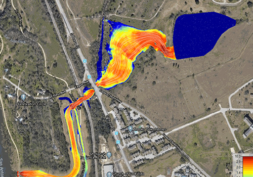
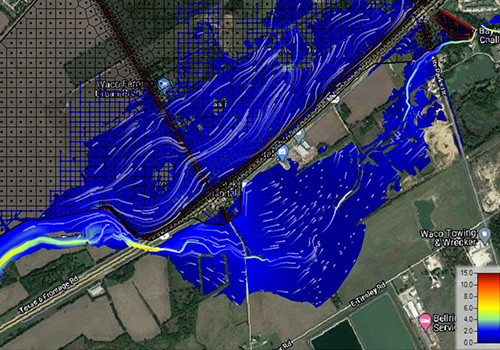
2D Modeling

We combine our expertise 1D/2D flood modeling and GIS to accurately define flood risk for infrastructure development and flood protection.

Land Development

We perform feasibility studies on land development projects and assist project from the platting to designing construction plans and estimating project costs.

Floodace and San Antonio River Authority​

Floodace is a sub-consultant for the Predictive Flood Modeling project, for the San Antonio River Authority. The purpose of the project is to prepare a 2-dimensional gridded model that simulates in near real time rainfall – runoff of all watersheds contributing to Bexar County flooding during storm events. During storm events, gauge adjusted Next Generation Radar (NEXRAD) rainfall will be brought over the prepared 2-dimensional model to predict where flooding problems will occur in Bexar County. This information will help the San Antonio/ Bexar County leadership decide where to commit their resources in the most efficient manner. 

About Us

Our team has a collective 60+ years of specializing in Water Resources Engineering, Infrastructure Asset Management, Web Application Development, Expert Testimony and Land Development.

0 +
Expert Testimony
0 +
Water Resource Engineering
0 +
Infrastructure Asset Management
0 +
Web Application Development

Our Works

Some of our Latest Projects

OUR EXPERTISE SPANS ACROSS TEXAS

Bexar County

City of San Antonio

City of Houston

City of Dallas

City of New Braunfels

City of Waco

City of San Marcos

City of Seguin